|
| at: |
Talladega National Forest |
Data from USFS GIS
 show on map
 animate
Trail users:


Elevation Profile
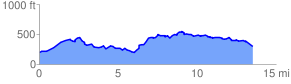
 14.038385 mi
 1659.14 ft
 1631.26 ft
 27.88 ft
 2.24 %
GPX Downloads: Track Route
![]()
|
| at: |
Talladega National Forest |
show on map
animate
14.038385 mi
1659.14 ft
1631.26 ft
27.88 ft
2.24 %