| at: |
Talladega National Forest |
Data from USFS GIS
 show on map
 animate
Trail users:


Elevation Profile
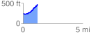
 1.215423 mi
 242.73 ft
 27.17 ft
 215.56 ft
 3.78 %
GPX Downloads: Track Route
![]()
| at: |
Talladega National Forest |
show on map
animate
1.215423 mi
242.73 ft
27.17 ft
215.56 ft
3.78 %