| at: |
Talladega National Forest |
Data from USFS GIS
 show on map
 animate
Trail users:


Elevation Profile
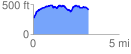
 3.282453 mi
 499.90 ft
 357.52 ft
 142.38 ft
 2.88 %
GPX Downloads: Track Route
![]()
| at: |
Talladega National Forest |
show on map
animate
3.282453 mi
499.90 ft
357.52 ft
142.38 ft
2.88 %