|
| at: |
Talladega National Forest |
Data from USFS GIS
 show on map
 animate
Trail users:


Elevation Profile
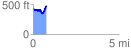
 0.799662 mi
 175.28 ft
 128.95 ft
 46.33 ft
 4.15 %
GPX Downloads: Track Route
![]()
|
| at: |
Talladega National Forest |
show on map
animate
0.799662 mi
175.28 ft
128.95 ft
46.33 ft
4.15 %