| at: |
Talladega National Forest |
Data from USFS GIS
 show on map
 animate
Trail users:


Elevation Profile
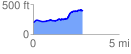
 2.888303 mi
 331.55 ft
 120.89 ft
 210.66 ft
 2.17 %
GPX Downloads: Track Route
![]()
| at: |
Talladega National Forest |
show on map
animate
2.888303 mi
331.55 ft
120.89 ft
210.66 ft
2.17 %