| at: |
Talladega National Forest |
Data from USFS GIS
 show on map
 animate
Trail users:


Elevation Profile
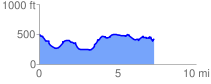
 7.431513 mi
 772.68 ft
 808.45 ft
 -35.77 ft
 2.06 %
GPX Downloads: Track Route
![]()
| at: |
Talladega National Forest |
show on map
animate
7.431513 mi
772.68 ft
808.45 ft
-35.77 ft
2.06 %