| at: |
Talladega National Forest |
Data from USFS GIS
 show on map
 animate
Trail users:


Elevation Profile
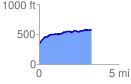
 3.266478 mi
 287.45 ft
 65.12 ft
 222.33 ft
 1.67 %
GPX Downloads: Track Route
![]()
| at: |
Talladega National Forest |
show on map
animate
3.266478 mi
287.45 ft
65.12 ft
222.33 ft
1.67 %