| at: |
Talladega National Forest |
Data from USFS GIS
 show on map
 animate
Trail users:


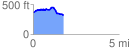
Elevation Profile
 1.761531 mi
 148.03 ft
 192.54 ft
 -44.51 ft
 2.07 %
GPX Downloads: Track Route
![]()
| at: |
Talladega National Forest |
show on map
animate
1.761531 mi
148.03 ft
192.54 ft
-44.51 ft
2.07 %