| at: |
Talladega National Forest |
Data from USFS GIS
 show on map
 animate
Trail users:


Elevation Profile
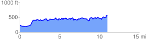
 11.126912 mi
 1481.65 ft
 1180.18 ft
 301.47 ft
 2.52 %
GPX Downloads: Track Route
![]()
| at: |
Talladega National Forest |
show on map
animate
11.126912 mi
1481.65 ft
1180.18 ft
301.47 ft
2.52 %