|
| at: |
Talladega National Forest |
Data from USFS GIS
 show on map
 animate
Trail users:


Elevation Profile
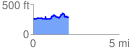
 2.067649 mi
 276.86 ft
 239.47 ft
 37.39 ft
 2.54 %
GPX Downloads: Track Route
![]()
|
| at: |
Talladega National Forest |
show on map
animate
2.067649 mi
276.86 ft
239.47 ft
37.39 ft
2.54 %