|
| at: |
Talladega National Forest |
Data from USFS GIS
 show on map
 animate
Trail users:


Elevation Profile
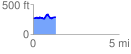
 1.313122 mi
 147.87 ft
 126.44 ft
 21.43 ft
 2.13 %
GPX Downloads: Track Route
![]()
|
| at: |
Talladega National Forest |
show on map
animate
1.313122 mi
147.87 ft
126.44 ft
21.43 ft
2.13 %