|
| at: |
Talladega National Forest |
Data from USFS GIS
 show on map
 animate
Trail users:


Elevation Profile
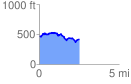
 2.534584 mi
 297.05 ft
 335.70 ft
 -38.65 ft
 2.51 %
GPX Downloads: Track Route
![]()
|
| at: |
Talladega National Forest |
show on map
animate
2.534584 mi
297.05 ft
335.70 ft
-38.65 ft
2.51 %