|
| at: |
Talladega National Forest |
Data from USFS GIS
 show on map
 animate
Trail users:


Elevation Profile
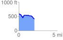
 2.107934 mi
 147.69 ft
 322.47 ft
 -174.78 ft
 2.90 %
GPX Downloads: Track Route
![]()
|
| at: |
Talladega National Forest |
show on map
animate
2.107934 mi
147.69 ft
322.47 ft
-174.78 ft
2.90 %