|
| at: |
Talladega National Forest |
Data from USFS GIS
 show on map
 animate
Trail users:


Elevation Profile
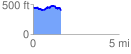
 1.662252 mi
 286.12 ft
 333.29 ft
 -47.17 ft
 3.80 %
GPX Downloads: Track Route
![]()
|
| at: |
Talladega National Forest |
show on map
animate
1.662252 mi
286.12 ft
333.29 ft
-47.17 ft
3.80 %