|
| at: |
Talladega National Forest |
Data from USFS GIS
 show on map
 animate
Trail users:


Elevation Profile
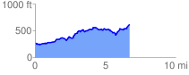
 6.852529 mi
 887.89 ft
 539.00 ft
 348.89 ft
 2.45 %
GPX Downloads: Track Route
![]()
|
| at: |
Talladega National Forest |
show on map
animate
6.852529 mi
887.89 ft
539.00 ft
348.89 ft
2.45 %