|
| at: |
Talladega National Forest |
Data from USFS GIS
 show on map
 animate
Trail users:


Elevation Profile
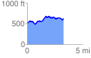
 3.343911 mi
 476.78 ft
 363.69 ft
 113.10 ft
 2.70 %
GPX Downloads: Track Route
![]()
|
| at: |
Talladega National Forest |
show on map
animate
3.343911 mi
476.78 ft
363.69 ft
113.10 ft
2.70 %