|
| at: |
Talladega National Forest |
Data from USFS GIS
 show on map
 animate
Trail users:


Elevation Profile
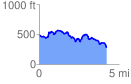
 4.270996 mi
 646.85 ft
 830.18 ft
 -183.32 ft
 3.68 %
GPX Downloads: Track Route
![]()
|
| at: |
Talladega National Forest |
show on map
animate
4.270996 mi
646.85 ft
830.18 ft
-183.32 ft
3.68 %