|
| at: |
Blue Ridge WMA |
Data from David Muse
 show on map
 animate
Trail users:


Elevation Profile
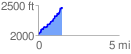
 1.489279 mi
 475.80 ft
 29.60 ft
 446.20 ft
 6.05 %
GPX Downloads: Track Route
![]()
|
| at: |
Blue Ridge WMA |
show on map
animate
1.489279 mi
475.80 ft
29.60 ft
446.20 ft
6.05 %