|
| at: |
Talladega National Forest |
Data from USFS GIS
 show on map
 animate
Trail users:


Elevation Profile
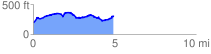
 5.000331 mi
 574.06 ft
 426.97 ft
 147.09 ft
 2.17 %
GPX Downloads: Track Route
![]()
|
| at: |
Talladega National Forest |
show on map
animate
5.000331 mi
574.06 ft
426.97 ft
147.09 ft
2.17 %