|
| at: |
Talladega National Forest |
Data from USFS GIS
 show on map
 animate
Trail users:


Elevation Profile
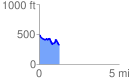
 1.282095 mi
 105.24 ft
 278.58 ft
 -173.34 ft
 4.12 %
GPX Downloads: Track Route
![]()
|
| at: |
Talladega National Forest |
show on map
animate
1.282095 mi
105.24 ft
278.58 ft
-173.34 ft
4.12 %