|
| at: |
Talladega National Forest |
Data from USFS GIS
 show on map
 animate
Trail users:


Elevation Profile
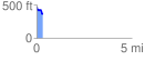
 0.348173 mi
 7.25 ft
 104.07 ft
 -96.82 ft
 5.66 %
GPX Downloads: Track Route
![]()
|
| at: |
Talladega National Forest |
show on map
animate
0.348173 mi
7.25 ft
104.07 ft
-96.82 ft
5.66 %