|
| at: |
Talladega National Forest |
Data from USFS GIS
 show on map
 animate
Trail users:


Elevation Profile
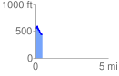
 0.488519 mi
 55.75 ft
 158.98 ft
 -103.23 ft
 6.16 %
GPX Downloads: Track Route
![]()
|
| at: |
Talladega National Forest |
show on map
animate
0.488519 mi
55.75 ft
158.98 ft
-103.23 ft
6.16 %