|
| at: |
Talladega National Forest |
Data from USFS GIS
 show on map
 animate
Trail users:


Elevation Profile
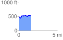
 1.570985 mi
 177.40 ft
 152.66 ft
 24.73 ft
 2.14 %
GPX Downloads: Track Route
![]()
|
| at: |
Talladega National Forest |
show on map
animate
1.570985 mi
177.40 ft
152.66 ft
24.73 ft
2.14 %