|
| at: |
Talladega National Forest |
Data from USFS GIS
 show on map
 animate
Trail users:


Elevation Profile
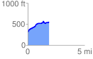
 1.890380 mi
 294.80 ft
 71.50 ft
 223.29 ft
 2.95 %
GPX Downloads: Track Route
![]()
|
| at: |
Talladega National Forest |
show on map
animate
1.890380 mi
294.80 ft
71.50 ft
223.29 ft
2.95 %