|
| at: |
Talladega National Forest |
Data from USFS GIS
 show on map
 animate
Trail users:


Elevation Profile
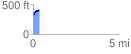
 0.357898 mi
 90.40 ft
 2.56 ft
 87.84 ft
 4.78 %
GPX Downloads: Track Route
![]()
|
| at: |
Talladega National Forest |
show on map
animate
0.357898 mi
90.40 ft
2.56 ft
87.84 ft
4.78 %