|
| at: |
Talladega National Forest |
Data from USFS GIS
 show on map
 animate
Trail users:


Elevation Profile
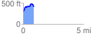
 0.867268 mi
 221.56 ft
 104.76 ft
 116.80 ft
 4.84 %
GPX Downloads: Track Route
![]()
|
| at: |
Talladega National Forest |
show on map
animate
0.867268 mi
221.56 ft
104.76 ft
116.80 ft
4.84 %