|
| at: |
Talladega National Forest |
Data from USFS GIS
 show on map
 animate
Trail users:


Elevation Profile
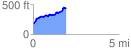
 1.901018 mi
 344.00 ft
 94.87 ft
 249.12 ft
 3.43 %
GPX Downloads: Track Route
![]()
|
| at: |
Talladega National Forest |
show on map
animate
1.901018 mi
344.00 ft
94.87 ft
249.12 ft
3.43 %