|
| at: |
Talladega National Forest |
Data from USFS GIS
 show on map
 animate
Trail users:


Elevation Profile
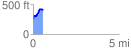
 0.582351 mi
 190.11 ft
 23.00 ft
 167.11 ft
 6.18 %
GPX Downloads: Track Route
![]()
|
| at: |
Talladega National Forest |
show on map
animate
0.582351 mi
190.11 ft
23.00 ft
167.11 ft
6.18 %