|
| at: |
Talladega National Forest |
Data from USFS GIS
 show on map
 animate
Trail users:


Elevation Profile
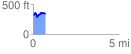
 0.718441 mi
 123.65 ft
 117.38 ft
 6.27 ft
 3.26 %
GPX Downloads: Track Route
![]()
|
| at: |
Talladega National Forest |
show on map
animate
0.718441 mi
123.65 ft
117.38 ft
6.27 ft
3.26 %