|
| at: |
Talladega National Forest |
Data from USFS GIS
 show on map
 animate
Trail users:


Elevation Profile
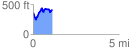
 1.117812 mi
 310.66 ft
 258.46 ft
 52.20 ft
 5.26 %
GPX Downloads: Track Route
![]()
|
| at: |
Talladega National Forest |
show on map
animate
1.117812 mi
310.66 ft
258.46 ft
52.20 ft
5.26 %