|
| at: |
Talladega National Forest |
Data from USFS GIS
 show on map
 animate
Trail users:


Elevation Profile
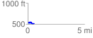
 0.556714 mi
 27.71 ft
 57.48 ft
 -29.77 ft
 1.96 %
GPX Downloads: Track Route
![]()
|
| at: |
Talladega National Forest |
show on map
animate
0.556714 mi
27.71 ft
57.48 ft
-29.77 ft
1.96 %