|
| at: |
Talladega National Forest |
Data from USFS GIS
 show on map
 animate
Trail users:


Elevation Profile
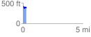
 0.298489 mi
 29.68 ft
 76.09 ft
 -46.40 ft
 4.83 %
GPX Downloads: Track Route
![]()
|
| at: |
Talladega National Forest |
show on map
animate
0.298489 mi
29.68 ft
76.09 ft
-46.40 ft
4.83 %