|
| at: |
Talladega National Forest |
Data from USFS GIS
 show on map
 animate
Trail users:


Elevation Profile
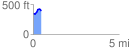
 0.487826 mi
 86.82 ft
 59.38 ft
 27.44 ft
 3.37 %
GPX Downloads: Track Route
![]()
|
| at: |
Talladega National Forest |
show on map
animate
0.487826 mi
86.82 ft
59.38 ft
27.44 ft
3.37 %