|
| at: |
Talladega National Forest |
Data from USFS GIS
 show on map
 animate
Trail users:


Elevation Profile
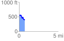
 0.737663 mi
 75.54 ft
 224.91 ft
 -149.37 ft
 5.77 %
GPX Downloads: Track Route
![]()
|
| at: |
Talladega National Forest |
show on map
animate
0.737663 mi
75.54 ft
224.91 ft
-149.37 ft
5.77 %