|
| at: |
Talladega National Forest |
Data from USFS GIS
 show on map
 animate
Trail users:


Elevation Profile
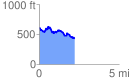
 2.232856 mi
 283.39 ft
 484.91 ft
 -201.53 ft
 4.11 %
GPX Downloads: Track Route
![]()
|
| at: |
Talladega National Forest |
show on map
animate
2.232856 mi
283.39 ft
484.91 ft
-201.53 ft
4.11 %