|
| at: |
Talladega National Forest |
Data from USFS GIS
 show on map
 animate
Trail users:


Elevation Profile
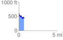
 0.692897 mi
 62.91 ft
 240.86 ft
 -177.94 ft
 6.58 %
GPX Downloads: Track Route
![]()
|
| at: |
Talladega National Forest |
show on map
animate
0.692897 mi
62.91 ft
240.86 ft
-177.94 ft
6.58 %