|
| at: |
Talladega National Forest |
Data from USFS GIS
 show on map
 animate
Trail users:


Elevation Profile
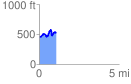
 1.059156 mi
 232.69 ft
 172.86 ft
 59.82 ft
 4.16 %
GPX Downloads: Track Route
![]()
|
| at: |
Talladega National Forest |
show on map
animate
1.059156 mi
232.69 ft
172.86 ft
59.82 ft
4.16 %