|
| at: |
Talladega National Forest |
Data from USFS GIS
 show on map
 animate
Trail users:


Elevation Profile
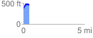
 0.455279 mi
 123.48 ft
 46.12 ft
 77.36 ft
 5.14 %
GPX Downloads: Track Route
![]()
|
| at: |
Talladega National Forest |
show on map
animate
0.455279 mi
123.48 ft
46.12 ft
77.36 ft
5.14 %