|
| at: |
Talladega National Forest |
Data from USFS GIS
 show on map
 animate
Trail users:


Elevation Profile
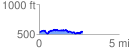
 2.721032 mi
 256.20 ft
 240.99 ft
 15.21 ft
 1.78 %
GPX Downloads: Track Route
![]()
|
| at: |
Talladega National Forest |
show on map
animate
2.721032 mi
256.20 ft
240.99 ft
15.21 ft
1.78 %