| at: |
Blue Ridge WMA |
Data from David Muse
 show on map
 animate
Trail users:


Elevation Profile
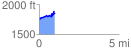
 0.976800 mi
 217.49 ft
 117.56 ft
 99.94 ft
 4.22 %
GPX Downloads: Track Route
![]()
| at: |
Blue Ridge WMA |
show on map
animate
0.976800 mi
217.49 ft
117.56 ft
99.94 ft
4.22 %