|
| at: |
Talladega National Forest |
Data from USFS GIS
 show on map
 animate
Trail users:


Elevation Profile
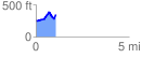
 1.085141 mi
 259.71 ft
 134.62 ft
 125.09 ft
 4.53 %
GPX Downloads: Track Route
![]()
|
| at: |
Talladega National Forest |
show on map
animate
1.085141 mi
259.71 ft
134.62 ft
125.09 ft
4.53 %