|
| at: |
Talladega National Forest |
Data from USFS GIS
 show on map
 animate
Trail users:


Elevation Profile
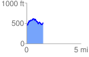
 1.606522 mi
 314.50 ft
 320.36 ft
 -5.87 ft
 3.78 %
GPX Downloads: Track Route
![]()
|
| at: |
Talladega National Forest |
show on map
animate
1.606522 mi
314.50 ft
320.36 ft
-5.87 ft
3.78 %