|
| at: |
Talladega National Forest |
Data from USFS GIS
 show on map
 animate
Trail users:


Elevation Profile
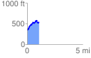
 1.083971 mi
 301.31 ft
 115.73 ft
 185.58 ft
 5.26 %
GPX Downloads: Track Route
![]()
|
| at: |
Talladega National Forest |
show on map
animate
1.083971 mi
301.31 ft
115.73 ft
185.58 ft
5.26 %