|
| at: |
Talladega National Forest |
Data from USFS GIS
 show on map
 animate
Trail users:


Elevation Profile
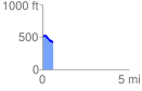
 0.606988 mi
 29.08 ft
 116.81 ft
 -87.73 ft
 3.64 %
GPX Downloads: Track Route
![]()
|
| at: |
Talladega National Forest |
show on map
animate
0.606988 mi
29.08 ft
116.81 ft
-87.73 ft
3.64 %