|
| at: |
Talladega National Forest |
Data from USFS GIS
 show on map
 animate
Trail users:


Elevation Profile
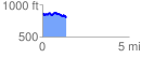
 1.381056 mi
 205.23 ft
 260.23 ft
 -55.00 ft
 3.57 %
GPX Downloads: Track Route
![]()
|
| at: |
Talladega National Forest |
show on map
animate
1.381056 mi
205.23 ft
260.23 ft
-55.00 ft
3.57 %