|
| at: |
Talladega National Forest |
Data from USFS GIS
 show on map
 animate
Trail users:


Elevation Profile
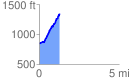
 1.290911 mi
 536.67 ft
 30.53 ft
 506.14 ft
 7.87 %
GPX Downloads: Track Route
![]()
|
| at: |
Talladega National Forest |
show on map
animate
1.290911 mi
536.67 ft
30.53 ft
506.14 ft
7.87 %