| at: |
Talladega National Forest |
Data from USFS GIS
 show on map
 animate
Trail users:


Elevation Profile
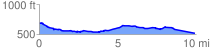
 9.964235 mi
 297.71 ft
 461.09 ft
 -163.38 ft
 0.88 %
GPX Downloads: Track Route
![]()
| at: |
Talladega National Forest |
show on map
animate
9.964235 mi
297.71 ft
461.09 ft
-163.38 ft
0.88 %