|
| at: |
Talladega National Forest |
Data from USFS GIS
 show on map
 animate
Trail users:


Elevation Profile
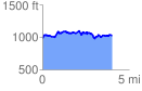
 4.029309 mi
 626.71 ft
 598.12 ft
 28.59 ft
 2.95 %
GPX Downloads: Track Route
![]()
|
| at: |
Talladega National Forest |
show on map
animate
4.029309 mi
626.71 ft
598.12 ft
28.59 ft
2.95 %