|
| at: |
Blue Ridge WMA |
Data from David Muse
 show on map
 animate
Trail users:


Elevation Profile
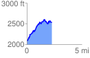
 2.240505 mi
 837.07 ft
 390.75 ft
 446.33 ft
 7.08 %
GPX Downloads: Track Route
![]()
|
| at: |
Blue Ridge WMA |
show on map
animate
2.240505 mi
837.07 ft
390.75 ft
446.33 ft
7.08 %