|
| at: |
Talladega National Forest |
Data from USFS GIS
 show on map
 animate
Trail users:


Elevation Profile
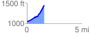
 1.591351 mi
 436.06 ft
 38.70 ft
 397.36 ft
 5.19 %
GPX Downloads: Track Route
![]()
|
| at: |
Talladega National Forest |
show on map
animate
1.591351 mi
436.06 ft
38.70 ft
397.36 ft
5.19 %